· 3 min read
Google find expands understanding of Nebraska’s icy past

By analyzing Google Earth images, a trio of Conservation and Survey Division scientists discovered that permafrost was common in northern Nebraska about 26,500 to 19,000 years ago when ice sheets were last at their greatest extent across North America.
The discovery adds another dimension to the study of changing climates in Nebraska and the surrounding Great Plains, said Matt Joeckel, director of the Conservation and Survey Division and co-author on the study, which published in the fall edition of Great Plains Research.
The team — Joeckel; Paul Hanson, geologist; and Les Howard, geographic information systems and cartography manager — combed through Google Earth images covering hundreds of square miles across Nebraska and South Dakota.
“We were stunned to find the evidence for ancient polygonal ground hiding in plain sight on the modern landscape — and in a few hundred places,” Joeckel said. “This is, by far, the best and most widespread evidence anyone has yet found for permafrost in Nebraska during the Last Glacial Maximum or, for that matter, at any other time during the Pleistocene ice ages.”
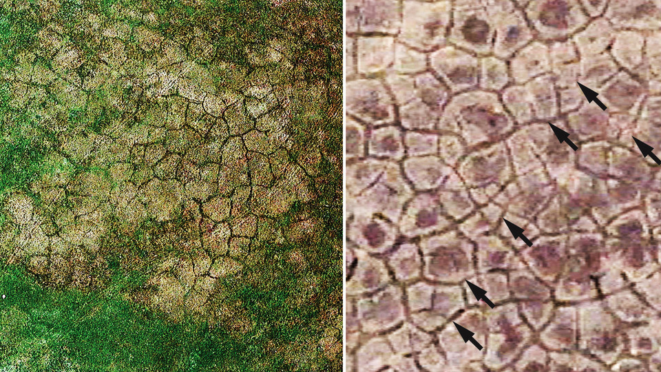
Polygonal ground describes the mosaic-like pattern of four- to seven-sided figures — tens of feet across — that can remain at the land surface after permafrost has melted away. It is caused by the contraction of soil and bedrock under very cold climatic conditions, a cold more intense and prolonged than the coldest winter modern Nebraskans have experienced. As the ground contracts, the cracks develop, only to be filled by a combination of ice and soil or sand. When the ice melts away, the sediment in the cracks remains, preserving a record of former permafrost.
The researchers found visual evidence of these cracks in the Google Earth images, but only in those taken during certain months and years, mostly springtime, and under particular conditions of soil moisture, land use/cropping and vegetation growth, the researchers said. The vast majority of aerial images did not capture the phenomenon, necessitating an exhaustive search through many years of images.
The researchers said the polygonal ground is always there at the land surface and extending just below it, and it may just be covered by vegetation or the difference in soil moisture is not great enough to highlight. The same ephemeral visibility of polygonal ground has been noted by others based elsewhere in North America and Europe.
The researchers plan to extend the research northward into South Dakota and also examine ancient periglacial features and climates across the Great Plains.
This discovery, and any from their future research plans, were possible because of geologic mapping funded by the U. S. Geological Survey’s STATEMAP Cooperative Geologic Mapping Program, in which the Conservation and Survey Division has been involved for more than two decades.


