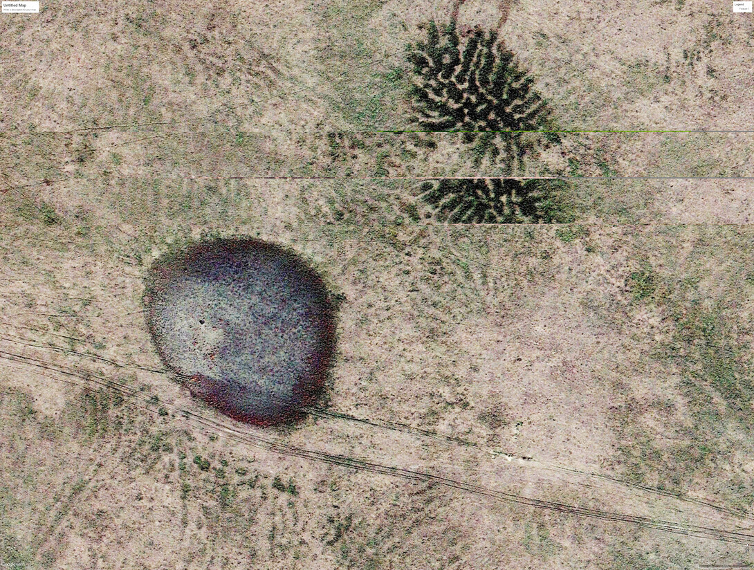
Two scientists with the University of Nebraska-Lincoln have identified gilgai, an unusual natural patterning of the land surface, for the first time in Nebraska.
Matt Joeckel and Les Howard of the School of Natural Resources' Conservation and Survey Division discovered the striking geologic pattern in the remote northern part of the Panhandle by examining high-resolution aerial photography in Google Earth. The find was published in the April 2018 issue of Great Plains Research.
More than 300 occurrences of the phenomenon were recorded in Sioux and Dawes counties. The majority of these occurrences are linear gilgai, which are low (probably less than about 20 inches in height), parallel ridges with even spacing. Shallow troughs appear between the ridges.
“In some places, the gilgai ridges gently curve and diverge from each other, forming elaborate and truly beautiful featherlike or fan-shaped patterns,” Joeckel said. “A very small amount of the gilgai appears as low, nearly circular pits and mounds on flattish hill summits; these depressions have been termed ‘normal gilgai’ by many authors.
“Though gilgai has been known since about 1960, if not earlier, from large areas of western South Dakota, it appears that it was never identified — or, much less, characterized — in Nebraska before."
The phenomenon has been identified in multiple states in the United States, but also in other countries, perhaps most famously Australia where the term “gilgai” originated; it means small watering hole. Gilgai is generally thought to form when clayey soils experience, over millennia, repetitive cycles of drying and wetting. Rainwater infiltrates deep soil cracks and causes swelling of the soil. The subsequent increase in soil volume at depth thrusts parts of the soil mass upward and sideway, forming a geometrically regular pattern of mounds or ridges, called microhighs, with shallow depressions or microlows at the land surface. Research has shown that gilgai can be obliterated, at least temporarily, by cultivation.
“Our observations suggest that gilgai microrelief in the study area has been compromised by cattle tracks and soil erosion” Joeckel and Howard wrote in their study. “(It) was likely more prominent prior to intense grazing” and erosion due to human land use, but it can form again within years to decades.
Gilgai contributes to the diversity of local and regional landscapes, with denser vegetation growing in the lows, and seasonal water basins forming in others. Gilgai influences land-surface hydrology and land use, and it can have negative impacts on roads and building foundations.
Still the discovery calls for more research on the origins and ecological associations of gilgai in Nebraska. Researchers in other parts of the world have found different plant communities and the highs and lows of gilgaied landscapes, suggesting a key role in local and regional biodiversity.
“This discovery further illustrates that Nebraska has a much more diverse landscape — and a much more compelling history of landscape evolution — than most laypeople and scientists seem to realize,” Joeckel said. “It’s exciting, and even affirming, to realize how much we still have to learn about Nebraska’s physical setting.”


