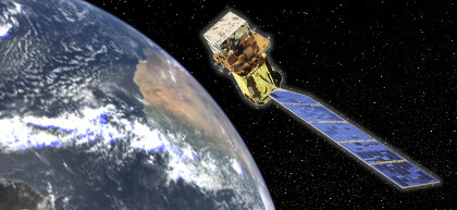
After a competitive nationwide process, the U.S. Geological Survey has named Ayse Kilic, UNL faculty member of the School of Natural Resources and Department of Civil Engineering, to the National Science Team supporting the new Landsat Data Continuity Mission Satellite.
The satellite is scheduled to launch in February from Vandenberg Air Force Base in California. The team of scientists and engineers will serve a five-year term, and provide technical and scientific input to USGS and NASA on issues critical to the success of the Landsat program.
Kilic’s contributions to the team will be in one of her research specialty areas: Developing and enhancing Landsat-derived evapotranspiration and surface energy products.
Now in its 40th year, the Landsat program is a series of Earth-observing satellite missions jointly managed by NASA and USGS. Since 1972, Landsat satellites have collected imagery of Earth’s continents and surrounding coastal regions, enabling researchers to study many aspects of our planet and to evaluate the dynamic changes caused by both natural processes and human practices.
“The team will form a science vanguard in advancing the analysis and application of Landsat data for science and resource management,” said Jim Irons, LDCM Project Scientist for NASA. “Their guidance will be invaluable as we plan for the long term future of the Landsat program.”
As recognized national and international leaders in land remote sensing, Landsat Science Team members will evaluate operational and data management strategies to meet the requirements of all Landsat users, including the needs of policy makers at all levels of government. They will play a key role in ensuring that the upcoming Landsat mission is successfully integrated with past, present, and future remotely sensed data for the purpose of observing national and global environmental conditions.
“I am, of course, very honored and excited at being selected to join the mission team,” Kilic said. “…And especially delighted because this is an opportunity to integrate the important research conducted at the University of Nebraska and to train more Nebraska students in the use of remotely sensed environmental and water resources data.”
Landsat provides images used for agricultural, forestry, and coastal management; insect, fire, and storm damage assessments; and urban, transportation, and water resources planning. The data gathered by these satellites are also used in regional agriculture, climate, and ecosystem modeling studies.
Kilic and her UNL research team and students will further the development of algorithms and computer software to estimate water consumption from irrigated and natural vegetation over large land areas.
“Landsat has ‘pixels’ that are 30 meters (100 feet) on a side, so we can view the consumption of water inside individual fields and also for the narrow systems of vegetation along streams and rivers,” Kilic said. “This type of spatial information helps the Natural Resources Districts of Nebraska and many other states manage their impacts and long-term sustainability on our water resources.”
Kilic and her research team at UNL have gained a national reputation for advances in producing information on water consumption using satellite images.