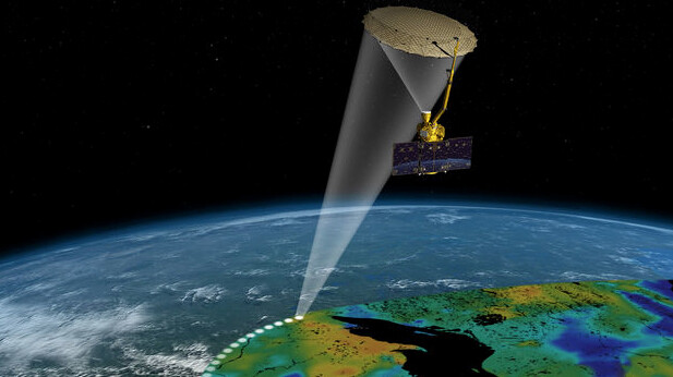
NASA has selected drought researchers at UNL to be among the first scientists to use data gathered by a satellite mission that launches Jan. 29.
The researchers are part of UNL’s National Drought Mitigation Center and the U.S. Drought Monitor. The project will include access to soil moisture data gathered by the new satellite.
“As we get these data at a high resolution, covering the entire country, we’re going to do our jobs better,” said Brian Fuchs, NDMC climatologist and U.S. Drought Monitor author. “When you see the Drought Monitor map coming out each week we’re going to have more confidence in some of the inputs that we’re looking at, especially with regards to soil moisture. They’re going to be of a high level, greater quality and more utility than anything we’ve had up to this point.”
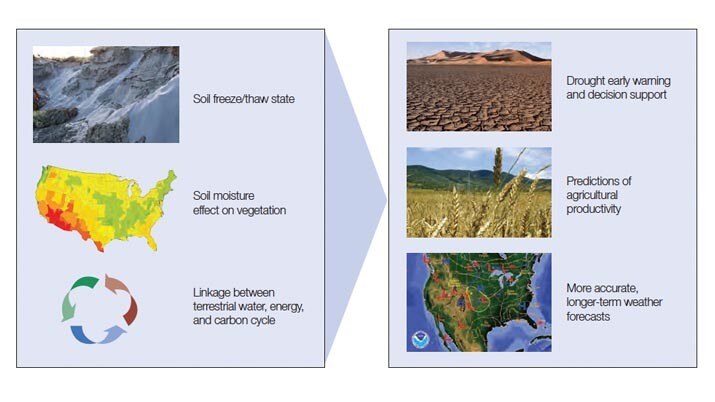
The NASA Soil Moisture Active Passive mission is expected to provide far better data about soil moisture information than anything that has been available to this point. Soil moisture, necessary for crops and other plants to grow, is a key indicator of agricultural drought.
“Soil moisture is really a critical component in understanding drought — where it’s developing, how severe it is,” said Brian Wardlow, an expert on remote sensing of drought. “Traditionally, soil moisture information has been acquired by ground-based measurements or probes in the soil, which are few and far between. So we’re interested in SMAP to give us more detailed information on soil moisture variations across large areas, really fill in the gaps between where these sensors are on the ground and to give us a more detailed spatial view of how things are changing in the soil over time.”
Wardlow, who is affiliated with the NDMC, is director of the Center for Advanced Land Management Information Technologies, which is also based in UNL’s School of Natural Resources.
“This will help us better understand the global hydrologic system and how soil moisture relates to groundwater, surface water and stream flow,” said Mark Svoboda, who leads the NDMC’s monitoring program area and is one of the original U.S. Drought Monitor authors. “It will help us do a better job of drought early warning.”
Svoboda and Wardlow said that as early adopters, they will be able to help provide guidance to NASA on how to make the SMAP data as useful as possible, within a drought monitoring context, to validate the accuracy and utility of the data for this application, and, assuming it is as accurate as anticipated, to help others use the data operationally in monitoring systems throughout the world.
NASA described SMAP as an orbiting observatory that will measure the water content of the top two inches of soil that is not frozen, and it will revisit most of the globe every few days. At six miles across, the pixels on SMAP-derived maps will be much smaller than the distance between soil monitoring sensors on the ground. In some of the most famine-prone parts of the world, little to no soil moisture information is currently available.
The NDMC research team has a history of working successfully with NASA on applications of its data for drought monitoring and early warning, including the Vegetation Drought Response Index, the Evaporative Stress Index and terrestrial water storage anomaly maps based on observations from the NASA GRACE mission.
To learn more about the SMAP mission, go to http://smap.jpl.nasa.gov.