Fair-weather fliers may be braving stormy weather when love is on the line and on the clock, says new research from the University of Nebraska–Lincoln.
Of the billions of birds that migrate annually, punching tickets for the tropics in the fall and northerly latitudes in the spring, the majority take to the skies only after the horizon has consumed the last slice of sun.
And with good reason. At night, the flocking migrants often contend with less turbulence and fewer predators. But their nocturnal flight schedules can’t put them beyond the reach of another potential peril: thunderstorms.

With help from graduate student Timothy Gunkel, Van Den Broeke set out to study how nocturnally migrating birds in eastern Nebraska, southern Indiana and eastern Iowa responded to isolated thunderstorms between 2013 and 2019.
More than 70% of the time in Nebraska and Indiana, meteorological radar revealed that the density of migrating birds was substantially lower in a thunderstorm’s wake — the stretch that the storm had just passed through. Van Den Broeke said the finding suggests that migrating birds in those areas may be going to the ground, or at least under the meteorological radar, to avoid danger when storms are overhead.
When the researchers compared the effect by season, though, they discovered a potentially telling difference: The reduction in density was measurably greater in the fall than the spring.
“We found that the birds we were looking at seem to worry more about thunderstorms in the fall,” said Van Den Broeke, whose research was funded by the National Science Foundation. “If migration conditions are not favorable in the fall, birds will tend to wait. In the spring, even if conditions aren’t as favorable, they’ll still tend to migrate.”
Why the difference? For birds, spring is the season of love, with many flying thousands of miles north to their annual breeding territories. Though the ground might be a convenient port in a storm, waiting out that storm might also mean arriving late for a date with a potential mate.
“They’re on a tighter migration schedule in the spring; they have to get to their breeding grounds by a certain time,” Van Den Broeke said. “In the fall, they can take their time as they work their way back toward the tropics. There isn’t as much of a time constraint.”
‘There’s a lot to learn’
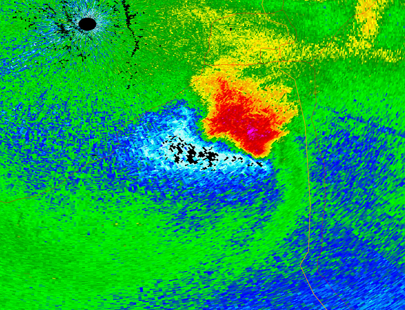
Van Den Broeke and Gunkel accumulated their data from the Weather Surveillance Radar-1988 Doppler network, the same one that the National Weather Service uses to track storms. Though the network has been providing operational data since 1992, two decades passed before it gained an innovation that would help meteorologists more reliably distinguish birds from precipitation and other weather signatures.
The radar has always worked by emitting cone-shaped bursts of electromagnetic waves and analyzing the characteristics of the waves that return, typically from the atmosphere. Before 2013, those waves were horizontally polarized, meaning that they generated electric fields only on the horizontal plane — and could capture data only from that one dimension.
The advent of so-called dual-pol radar added a polarization slanted at 45 degrees, allowing algorithms to piece together information from the vertical dimension, too. That, in turn, has given meteorologists and researchers about a half-dozen more variables to help them identify what the electromagnetic waves, which travel at the speed of light, are actually striking.
“So instead of just knowing there’s something out there, we can say: Is it liquid? Is it ice? Is it non-meteorological? How is it oriented? How much variability is there in the orientation of what we’re looking at in this volume of space?” Van Den Broeke said.
The relative youth of dual-pol radar could help explain why, as far as Van Den Broeke can tell, his study is the first to quantify the effects of thunderstorms on flock density. The technology does have its limits; it can’t distinguish among bird species, for one. But given its potential to complement or address research gaps left by radio tagging and other traditional bird-tracking techniques, Van Den Broeke said he expects similar studies to follow.
“When you tag a few birds, and they move, maybe they happen to interact with storms. Maybe they don’t,” he said. “The neat thing with radar is that we can actually say, ‘Yes, these are birds, and yes, we’re sampling millions of them in the domain of this radar.’ You can see how they’re interacting with storms on a bigger scale.
“So I think it’s an interesting method. I think there’s a lot to learn.”
Share
News Release Contact(s)
Related Links
Tags
High Resolution Photos
HIGH RESOLUTION PHOTOS