The University of Nebraska–Lincoln’s Nebraska Intelligent MoBile Unmanned Systems Lab, known as NIMBUS, has received nearly $2 million in funding to advance its work on an integrated suite of robotics and drone technologies that will push forward research in the state and around the world.
Two grants — one from the National Science Foundation, the other from the U.S. Department of Agriculture’s National Institute of Food and Agriculture — will enable NIMBUS researchers to push the boundaries of what robots can do and expand human understanding of how climate change is impacting agricultural, aquatic and wildland systems. Both projects will offer graduate and undergraduate students training opportunities at the forefront of robotics research.
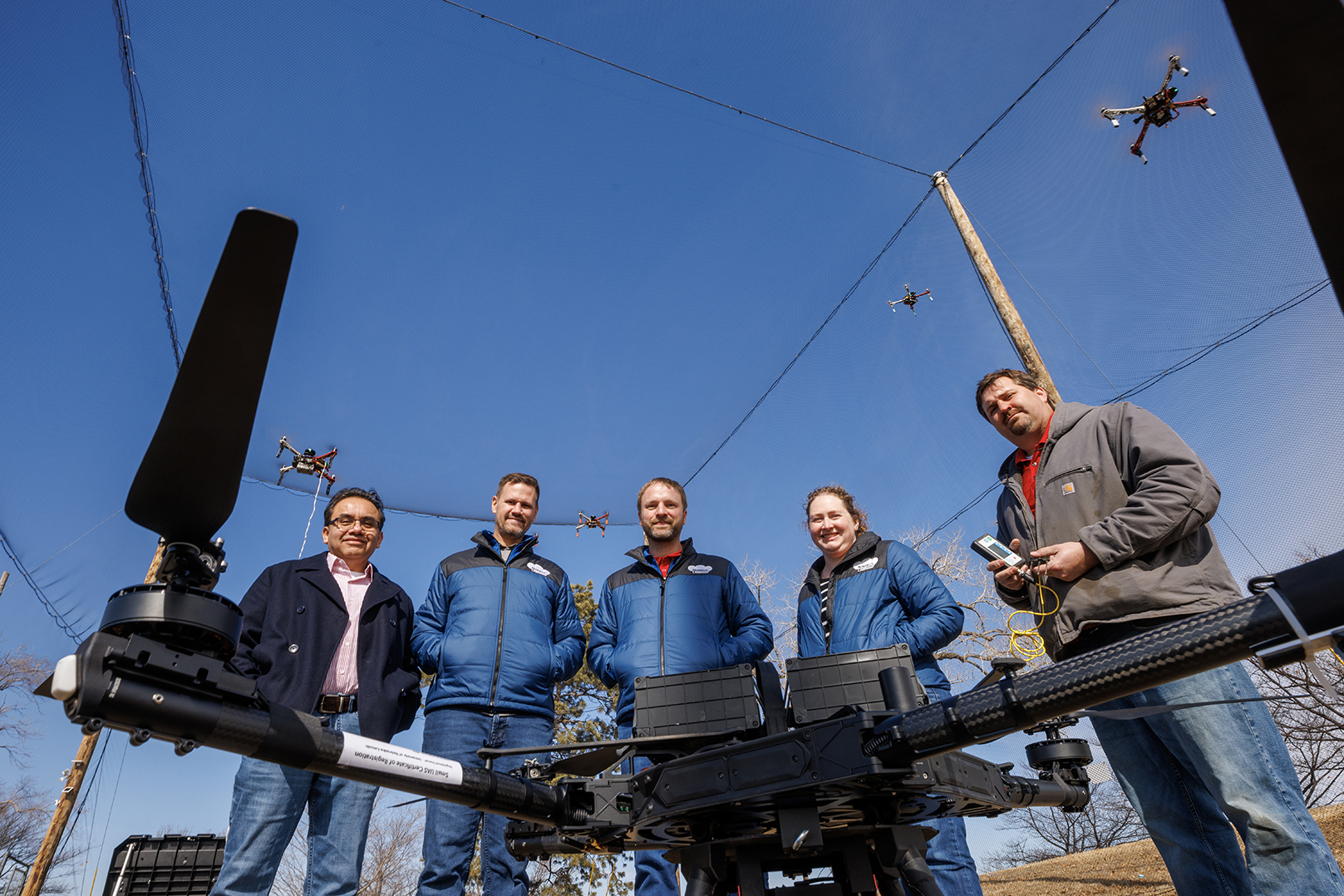
Brittany Duncan, Ross McCollum Associate Professor of computing, is leading the three-year NSF project, which is a collaboration with Ken Tape of the University of Alaska Fairbanks. The team, which also includes Husker researchers Justin Bradley and Carrick Detweiler, will develop an integrated robot system to collect ecosystem data in the Arctic tundra.
Over the past 20 years, climate change has made the Arctic more hospitable to North American beavers. Their colonization has changed the area’s environment and topography — most notably, their behavior is melting permafrost, which releases greenhouse gases into the air. These changes have important environmental implications but are difficult to study because of the remote terrain, need for underwater measurements and the beavers’ mixed aquatic-terrestrial habitats.
To overcome these hurdles, the NIMBUS team is devising a system where drones, boats and deployable underwater sensors work in tandem to reach these hard-to-access beaver ponds. The researchers have worked on all three types of unmanned vehicles before, but this is the first time they’ll integrate them in this way.
“This environment is very hard to traverse. It’s cluttered. Getting from one beaver pond to another is very difficult for the scientists right now,” Duncan said. “This will enable them to get to certain places that they can’t currently observe and gather more data that they couldn’t otherwise get.”
Detweiler, Susan J. Rosowski Professor of computing, will lead mechanical design of the vehicles, designing them so that the drones can drop off and retrieve boats, which are roughly the size of a suitcase and will be equipped with surface and underwater cameras.
The boats, in turn, will drop off and retrieve underwater sensors that can measure water properties and capture images of the beavers and their environment.
“We’re adapting systems that we have so they will work together in a way we haven’t thought about before,” Duncan said. “They’re nesting bowls of robots.”
Bradley is developing an innovative approach to give the robots a capacity for flexible, on-the-fly decision making. Based on input from scientists about what data and performance they’re seeking from the robots, he’ll develop what are essentially plans for robotic systems that can be updated on the spot, as circumstances change.
“The key innovation is to be able to do this as the machine is in the air or water,” said Bradley, associate professor of computing. “The reason to do this is (that) if the environment changes — and it does all the time — then you’d want to be able to adapt to that. This will enable a level of adaptivity that we don’t generally see in robotic systems.”
Duncan’s focus is on better understanding how users learn and acquire knowledge about operating the robots, particularly the boats and underwater sensors. This will help her develop better instruction and training approaches.
The team will test the system in progressively challenging environments, starting first with pools and ponds in Nebraska, then expanding to outdoor environments of variable winds and temperatures before ultimately launching the system in Alaska’s beaver ponds.
The three-year USDA project, led by Bradley, is focused on unlocking the potential of carbon sequestration, an approach to fighting climate change that compensates farmers for leaving land untilled. Because they are composed in part of broken-down plant matter, the top layers of soil store, or sequester, carbon. When farmers till their land — a breaking up of the soil to make way for new crops and fend off weeds — this carbon, a major greenhouse gas, is released into the environment.
To curb these carbon influxes, there are programs to compensate farmers for no-till agriculture. Individuals and companies looking to offset their carbon footprint can purchase carbon credits that profit growers engaging in climate-smart agriculture.
But a major barrier is the difficulty of quantifying how much carbon is actually stored in the soil. In carbon markets, this process is called monitoring, reporting and verification, or MRV, and currently it’s accomplished by sectioning a plot of land into squares and sending a person to dig a hole in each square to collect samples.
“It’s pretty laborious, it takes a lot of time, it’s costly, it’s potentially hazardous,” Bradley said. “It would be a big deal to be able to minimize those downsides.”
The team, which includes Detweiler and Husker scientists Trenton Franz and Francisco Muñoz-Arriola, aims to automate the process using a three-pronged approach. First, they will use a tethered drone, with sensors placed along the tether, to measure the volume of air over the field, including measurements of temperature, carbon dioxide, wind and other atmospheric traits. They will also develop an integrated drone system capable of gathering soil samples and placing water sensors.
Then, combining data from the tethered drone and the sampling drones, the team will develop a smart sampling strategy that pinpoints the locations that will yield the data most critical to MRV, which is key to scaling up the process and minimizing unnecessary work. These algorithms will be incorporated into a widely used USDA software tool.
A major innovation is the ability to compare data from the tethered drone to data from the sampling drones: If the two match, this indicates that atmospheric measurements accurately reflect the underlying soil’s water and organic carbon content.
“If you could tie data from the atmosphere to information about carbon in the soil, you could really drastically improve the ability to sample in a way that’s much easier than sending a person, or even a drone, out to the field,” Bradley said.
Atmospheric monitoring could be a valuable tool beyond farming and agriculture. It would enable carbon monitoring in places where the soil is inaccessible to researchers — for example, in the Costa Rican rainforests, where NIMBUS has an ongoing NSF-funded project with Texas A&M University and Iowa State University on monitoring carbon and water in the natural environment. It could also play a role in carbon monitoring at monoculture carbon farms, where there are questions about the levels of captured carbon.
Share
News Release Contact(s)
Related Links
Tags
High Resolution Photos
HIGH RESOLUTION PHOTOS