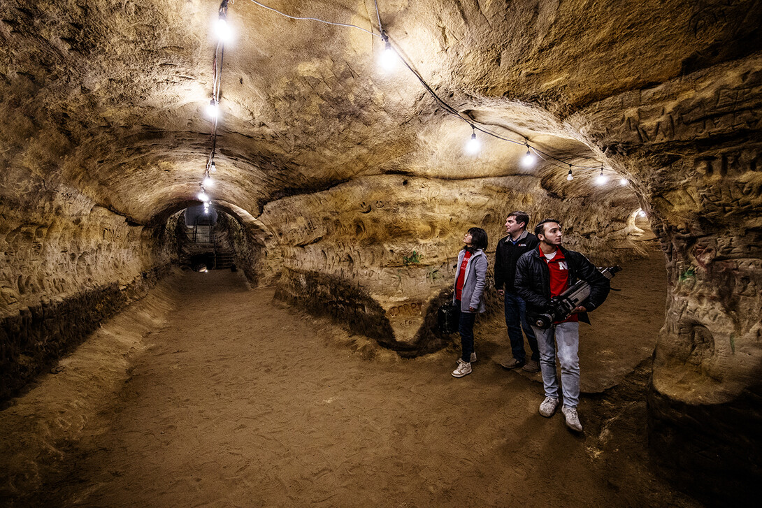
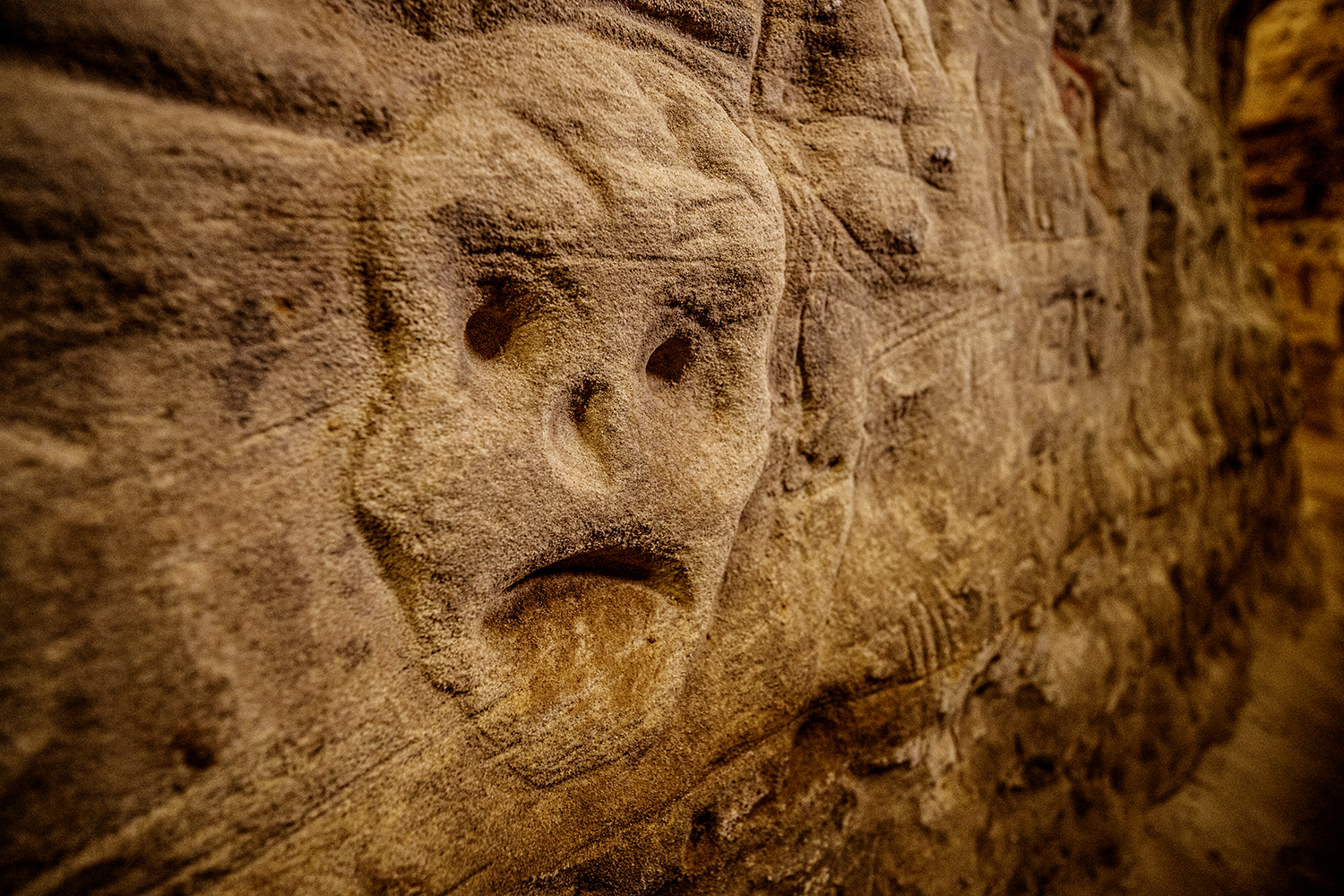
As bits of Robber’s Cave history fade to folklore, the thousands of engravings that crowd its Dakota sandstone walls like graffiti are likewise disintegrating, imperceptibly but inevitably, into miniature dunes at the base of the walls.
These walls can talk — echoing more than a century of visits from those who have carved names and symbols and faces with finger or stick or knife — but some of the distant voices are nearing whispers.
A first-of-its-kind project funded by History Nebraska and coordinated by the University of Nebraska–Lincoln’s Richard Wood is preserving those voices by digitally mapping every millimeter of the cave’s 5,000-plus square feet, engravings and all.
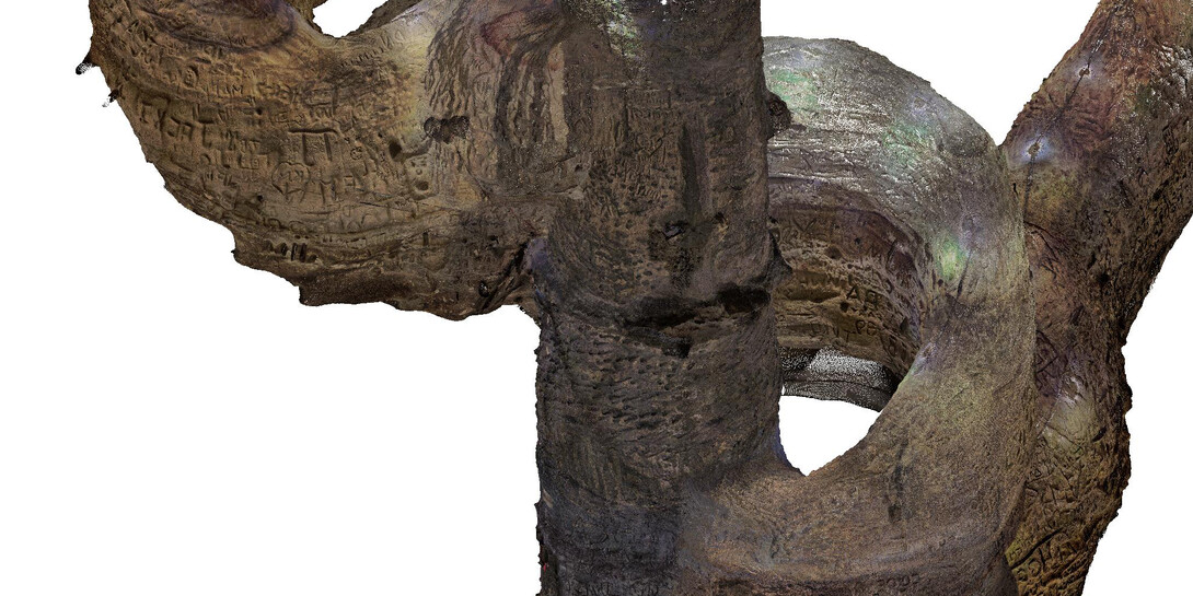
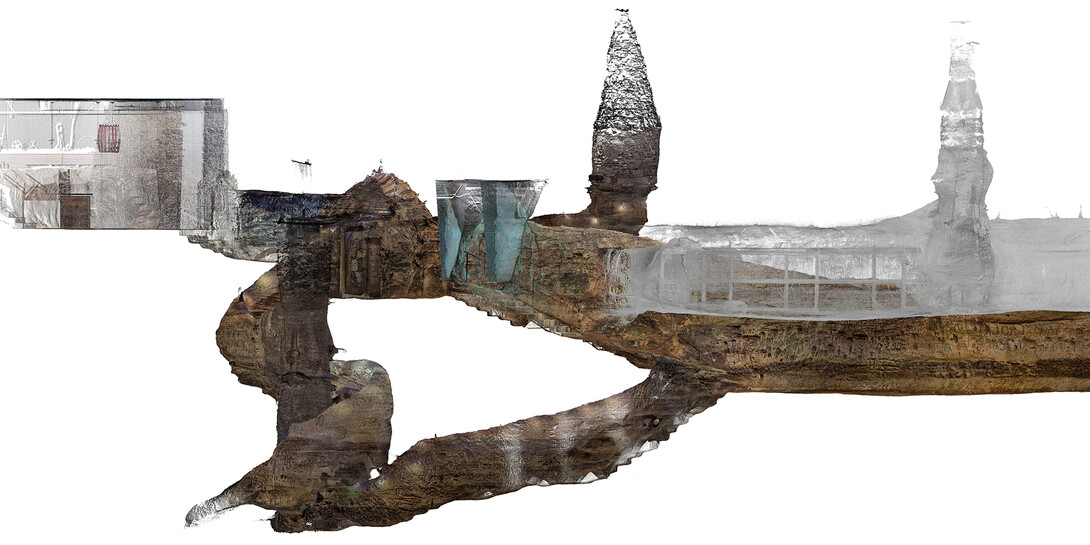
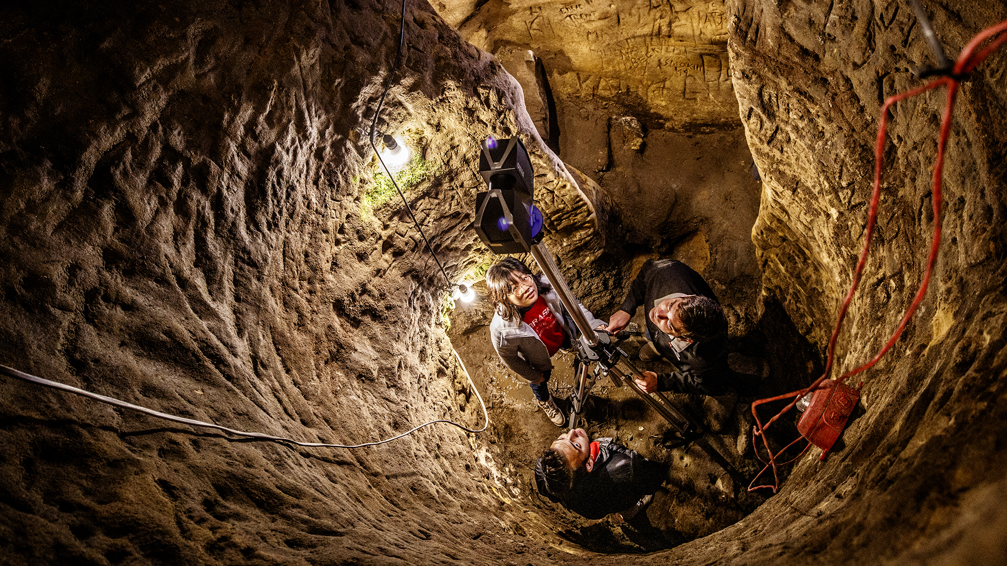
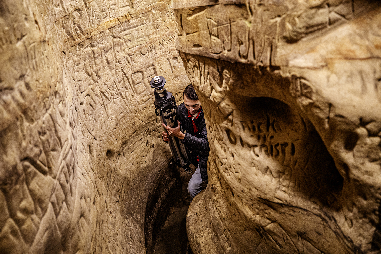
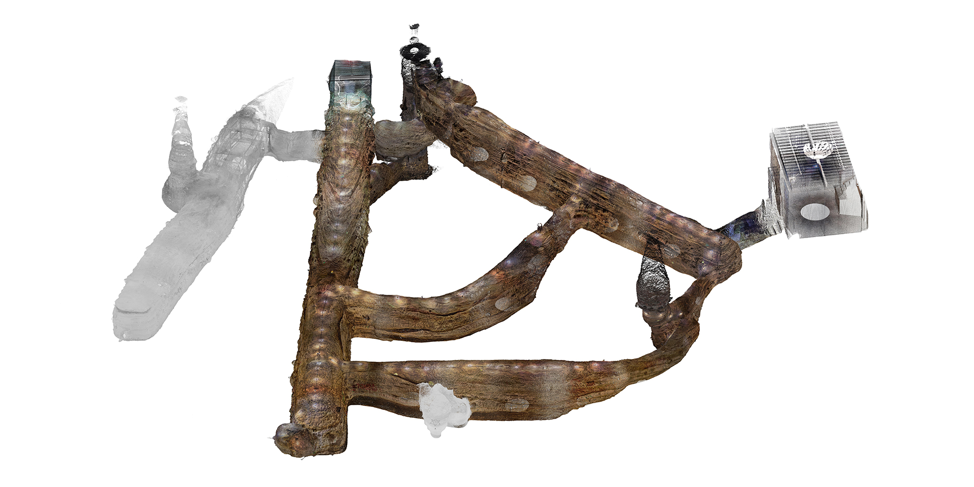
Wood and several Nebraska students have produced a 3D rendering of Robber’s Cave using light detection and ranging, or lidar, which fires near-infrared laser beams at a surface, measures the time they need to reflect and return from that surface, then calculates the distance to a given point.
By repeating the process at 92 locations throughout the cave to generate a 3D cloud of points — 3.1 billion of them — Wood’s team has managed to capture each contour of the cave’s uneven terrain, branching tunnels and multi-level architecture.

“This is the largest data collection my research group has ever done,” said the assistant professor of civil and environmental engineering, whose team used two portable scanners to map the cave over roughly 30 hours in September.
Some aspects and areas proved especially tricky, Wood said. Getting representative averages of the tunnels’ widths entailed digitally chopping them into more-cylindrical sections that could be measured more objectively. Mapping two vertical shafts, one of which acts as a de facto well, required a specialized tripod that lessened the otherwise-extreme angles at which the scanner fired its beams. Scanning a chamber that houses bats meant contending with protective screens and the dim red lights designed to accommodate its nocturnal residents.
“It actually was a fun challenge,” said Wood, who got plenty of help from doctoral student Yijun Liao, undergraduate student Dylan Downes and postdoctoral researcher M. Ebrahim Mohammadi.
The resulting 3D rendering will help History Nebraska make the case for adding Robber’s Cave to the National Register of Historic Places, said David Calease, who helps coordinate such efforts for the state agency. To Calease’s knowledge, the Robber’s Cave application ranks as the first to include a detailed digital rendering among its nomination materials.
“In most nominations, it’s, ‘We’re going to photograph this, that and the other,’” Calease said. “But with a place like this, it’s very difficult. You can take a picture, but it’s really hard to get that feel and understanding from it. This is such a unique place that we needed to do something different to really capture it.”
The scanning also represents a more general effort to digitally preserve the current state of the cave amid the subtle ravages of humidity, temperature and time. When humidity rises, moisture can work its way between layers of the sandstone, with even slight temperature fluctuations then driving expansion and contraction. Over time, that heaving eventually weakens the bonds among layers and primes the sandstone to flake off.
“When it dries and shrinks, the surface of the walls becomes brittle,” said John Rissetto, a preservation archaeologist with History Nebraska. “So if you have people down there even just walking by, the shaking of the ground will cause enough friction to just pop it off.
“As (this) continues, it’s going to decrease the depth of the engravings to the point where they’re no longer going to be visible.”
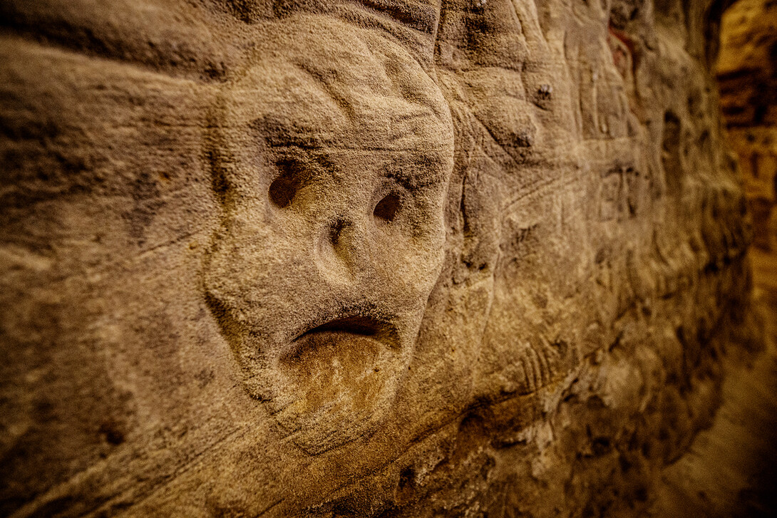

Those engravings and other markings help tell the tale of the cave, which began as a naturally occurring but shallow formation that was expanded into a storage cavern in 1869 by the owners of Nebraska’s first brewing company, Pioneers Brewery. Unconfirmed, often dubious reports boast of historic visitors: an injured Jesse James, slaves escaping to freedom via the Underground Railroad, Chuck Norris.
But former owner Ed Scarborough Jr. did treat one of the cave’s tunnels as a shooting range in the 1970s, explaining the bullet holes that pepper its walls. Fraternities, sororities, church groups, literary societies and other organizations did hold initiation ceremonies in the cave. Bands played there. People partied and played craps there. And many left evidence in the form of names, Greek letters, hearts, peace signs or other symbols not fit for print.
“A lot of people we talked to in Lincoln said, ‘Oh, yeah, I used to hang out there when I was younger,’ or, ‘I remember visiting with friends of mine,’” Rissetto said of the cave, which remains open for tours. “It is part of Lincoln’s history among a specific generation.”
The sheer number of engravings scrawled into the walls can almost overwhelm the eyes, which Rissetto said should make the digital rendering of Robber’s Cave especially valuable for those looking to unearth more of its history.
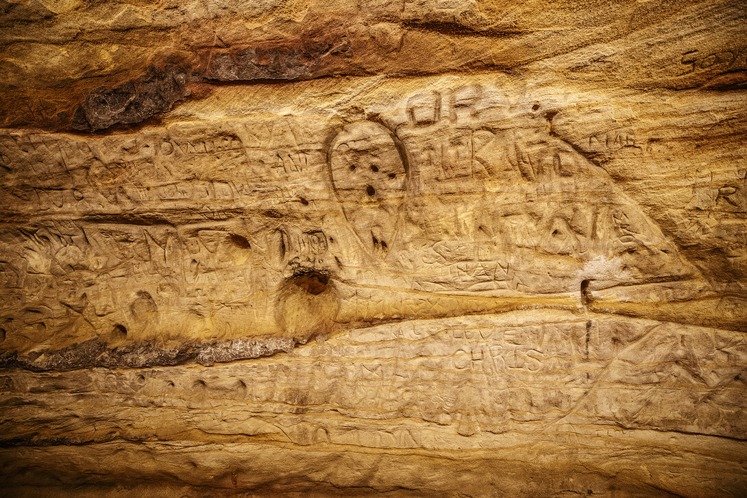
“The difficulty is that there are so many, it's hard to focus on individual ones, because your brain is constantly shifting to the next one,” he said. “Ultimately, we would love to have cultural anthropologists, historians, genealogists be able to analyze each individual engraving so that they can look up the names of people who were there. Because Willa Cather was supposed to be there. John Neihardt was supposed to be there. Any famous person who lived in Nebraska is said to have visited the cave at one time or another. The question is: Did they? And did they leave their name in there?”
Making the 3D rendering publicly available online, as the team eventually hopes to do, might also help drive tourism to the site when visiting Lincoln for a Husker football game or staying with relatives during the holidays, Rissetto said.
“It's the same way that the Statue of Liberty and the Eiffel Tower are also in 3D on the web, and people still go to those all the time,” he said. “It's just another interesting way to entice people to find these places and visit them. It’s part of a supplement, but it’s not a substitute.”
In the meantime, the team is putting its finishing touches on the National Register application and expects the National Park Service to return its verdict by mid-March.
Regardless of the verdict, Rissetto and Calease said History Nebraska hopes to continue collaborating with Wood’s team on future applications and other projects. Rissetto cited Chimney Rock as another Nebraska signature that, bearing the constant brunt of the elements, could benefit from the digital preservation of a lidar scan.
And the group said it foresees a future in which lidar-based renderings become common components of both National Register nominations and historical documentation more broadly.
“The National Park Service is going to get a copy of all the raw data so that they have it for their records, because that's what we're trying to establish,” Rissetto said. “We're trying to establish a baseline for how we do this going forward. And if we can get a 3D model of every single National Register property, that would be the goal.
“Because ultimately, in my opinion, it’s (about) trying to make history relevant, and this is the easiest way for us to do that. We’re recreating it so that people can see it and experience it.”
Mapping a Hidden Treasure by University of Nebraska–Lincoln on Exposure
Share
News Release Contact(s)
Related Links
Tags
High Resolution Photos
HIGH RESOLUTION PHOTOS
HIGH RESOLUTION PHOTOS
HIGH RESOLUTION PHOTOS
HIGH RESOLUTION PHOTOS