Nebraska’s rivers can be thought of in various ways: Places for quiet contemplation. Familiar local landmarks. Precious natural resources to be protected.
For Jesse Korus, the state’s rivers are all that, but they’re also something more: They are messengers from Nebraska’s deep geologic past. And their messages, discerned through innovative analysis of remnant river-channel deposits preserved in modern topography and rock outcrops, are important in helping Nebraskans understand the ongoing geological dynamics affecting the state.
Korus, an associate professor with the University of Nebraska–Lincoln’s School of Natural Resources, is deepening the knowledge of Nebraska’s geologic past by co-authoring two recent studies of ancient river systems on the Great Plains.
“This is the first time we’ve directly observed the courses of ancient river channels over a broad area of the Great Plains and related those to past landscapes and events,” Korus said.
One paper, published in Geosphere, a journal of the Geological Society of America, observes that Great Plains landscapes “are the products of a long-lived, continental sediment routing system” via rivers, “and yet strikingly little is known about these ancient rivers.” The paper by Korus and Matt
Joeckel, senior associate director of the School of Natural Resources and Nebraska state geologist, helps fill in the knowledge gap about the history of the Platte River’s ancestral river system from as long as 33 million years ago.
“The rivers were agents of construction of the Great Plains,” said Korus, who is also a groundwater geologist for the Nebraska Conservation and Survey Division. Joeckel is the CSD director.

A second paper by the two Husker scientists, published in The Sedimentary Record, a journal of the Society for Sedimentary Geology, explains how patterns of riverine sediment deposition from the Rocky Mountains down to the Gulf of Mexico convey key geologic information about upstream conditions. Enormous, fan-shaped sedimentary deposits in Nebraska’s ancient High Plains stabilized the river’s sediment delivery system, holding sediments for millions of years, and prevented climate fluctuations from rapidly altering the landscape in downstream areas, Korus and Joeckel wrote.
“These rivers carried not only the sediments and the water itself, but information about the geologic past — past environment, past events,” Korus said. “For example, uplift in the Rocky Mountains would have created a pulse of sediment that ultimately ended up as a thick sediment body deposited in the sink” far downstream in the Gulf of Mexico.
Giant “megafans” of sedimentation in ancient southwest Nebraska, as well as parts of Colorado and Wyoming, delayed that information transmission by acting as a “signal buffer,” Korus and Joeckel found. The vast fan-like structures, up to 56 miles wide, stored sediment eroded from the Rocky Mountains for perhaps as long as 5 million years before some of it was transported downstream. This geologic process delayed the riverine transmission of signals of uplift and climate change affecting the ancient river basin.
The Nebraska scientists’ analysis strengthens the understanding of how rivers respond to tectonic movement, geomorphic upheaval and climate change over geologic timescales. Their work also sets the stage for Korus and Joeckel to pursue expanded geologic analysis of western Nebraska, eastern Wyoming and northeast Colorado. Sediments exposed at the surface in those areas are analogous to the Ogallala Aquifer in the subsurface farther east. This future research can boost understanding of the aquifer, Nebraska’s preeminent natural resource.
Such study, Korus said, can “improve our understanding of deposits in the subsurface, the very deposits that are part of the High Plains Ogallala Aquifer. So it lends itself to an increased understanding of our great aquifer systems here in Nebraska.”

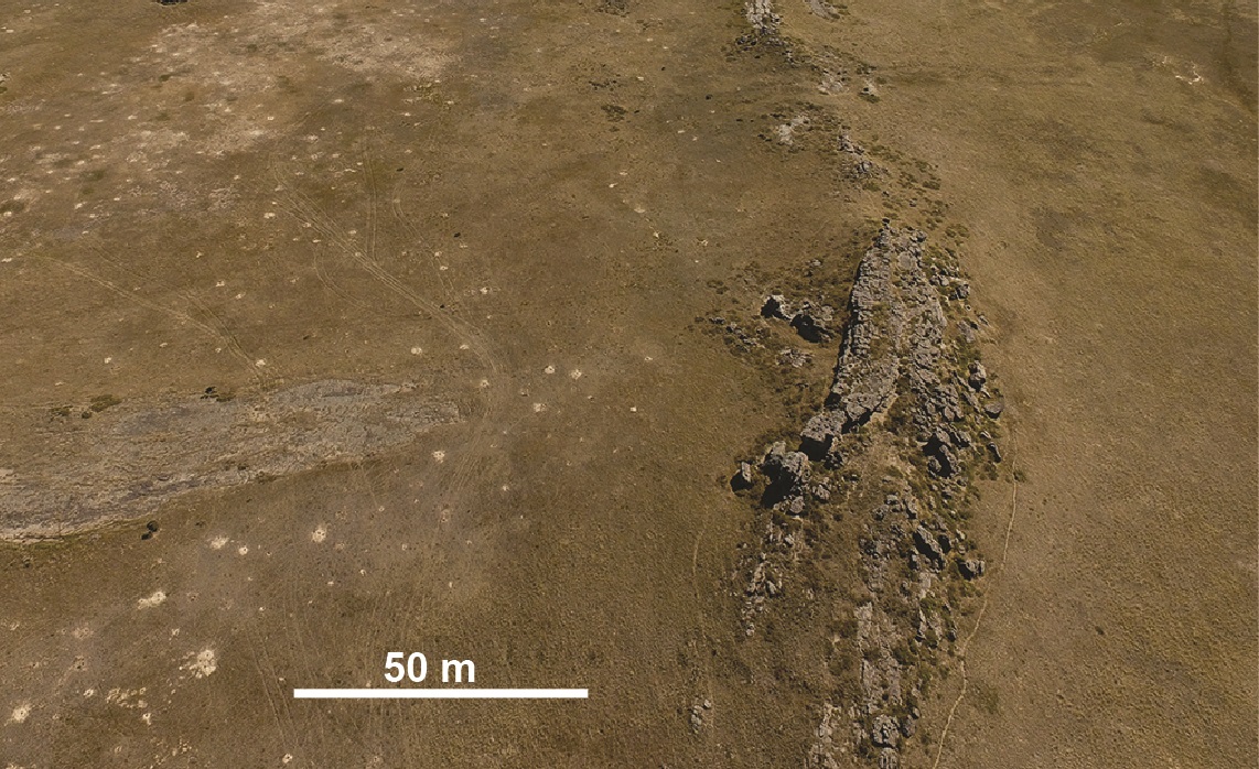
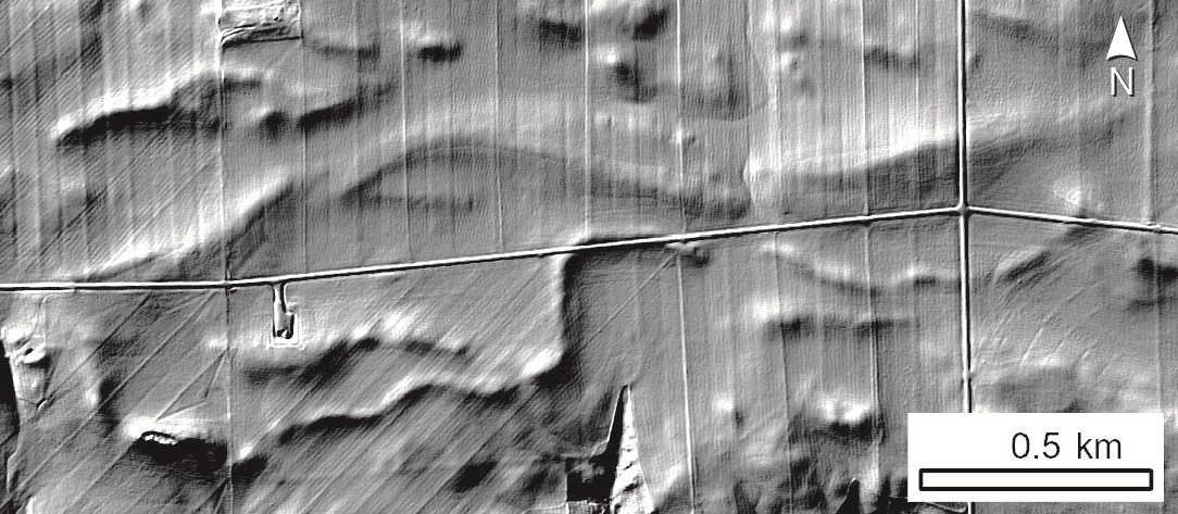
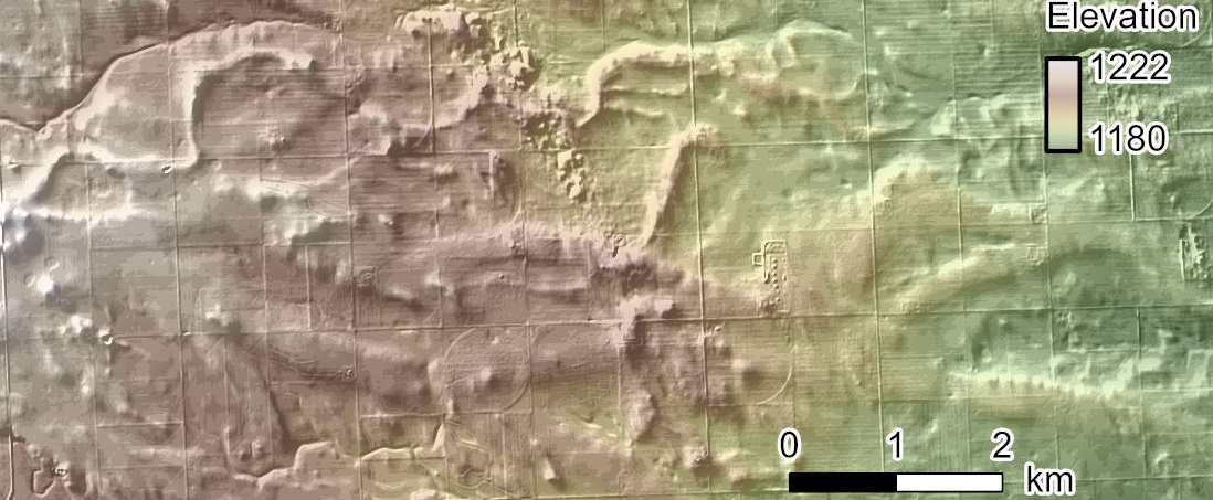
For both these projects, Korus and Joeckel used the remote-sensing technology known as lidar, or light detection and ranging, which enables analysis of the terrain in remarkably fine detail. For the first paper, Korus and Joeckel identified more than 3,100 fluvial ridges, the eroded remnants of ancient river channels that provide important information about ancient hydrology and drainage patterns.
Meticulous analysis of those “fossil rivers,” spanning from 2 million years ago to about 33 million years in the past, revealed the evolution of the Platte River system. It indicated that the streams of the ancient South Platte River system were initially small and diverse, following a course quite different from the modern river system.
“The earliest South Platte was far different than it is today,” Korus said. “Some rivers flowed from northwest to southeast, perpendicular to the modern South Platte River in eastern Colorado. That suggests that that river system wasn’t quite established yet. It was still in its earliest stages. Then, younger ridges show us that the rivers became larger, leading to the incision of the modern South Platte valley. Only after the modern route of the South Platte was established did the modern North Platte valley begin to develop.”
Understanding these ancient geologic details hinges on discerning the messages contained in Nebraska’s geology.
“Sediments and rocks in general can be read like a book, and they tell us about the geologic past,” Korus said.
The scientific work by Korus and Joeckel is adding new chapters to Nebraska’s geologic history, enabling a stronger understanding of the state’s environmental present and future.
Share
News Release Contact(s)
Related Links
Tags
High Resolution Photos
HIGH RESOLUTION PHOTOS
HIGH RESOLUTION PHOTOS
HIGH RESOLUTION PHOTOS