· 4 min read
Fires a growing threat to air quality, UNL scientist says

When a Canadian wildfire carried smoke more than 1,600 miles to Nebraska earlier this month, Jun Wang noted it as an example of how wildfires are a direct cause for concern, even among those who live many hundreds of miles away.
“This happens a couple of times a year and I expect we will see smoke from fires in California here later this summer,” said Wang, the Susan J. Rosowski Associate Professor of Earth and Atmospheric Sciences at the University of Nebraska-Lincoln. “Often we cannot do anything about it; you cannot put a wall there. The only thing we can do is forecast how much smoke is coming and when it will arrive and alert people.”
Wang uses satellite data to better understand how air pollution, particularly smoke caused by land management fires, affects the climate. One of only a handful of scientists in the United States doing this sort of research, Wang and his team have a unique combination in using satellites to detect fires and computers to simulate how smoke travels.
Scientists say El Niño and climate change are increasing the potential for wildfires. And prescribed burns, where conservationists deliberately start fires to burn away underbrush and debris, are an important tool to reduce the risk of more serious wildfires, Wang said. Yet even those can cause air quality concerns if they are not managed carefully.
“There are no boundaries in the air,” he said. “When you burn things, it affects others.”
Wang and his family were among those in the crowd at the May 7 Guardians of Freedom Air Show in Lincoln, when organizers grounded the U.S. Navy’s Blue Angels flight demonstration squadron because of the smoky haze. In April, smoke from prescribed fires in Kansas’ Flint Hills region led schools in eastern Nebraska to cancel students’ outdoor activities.
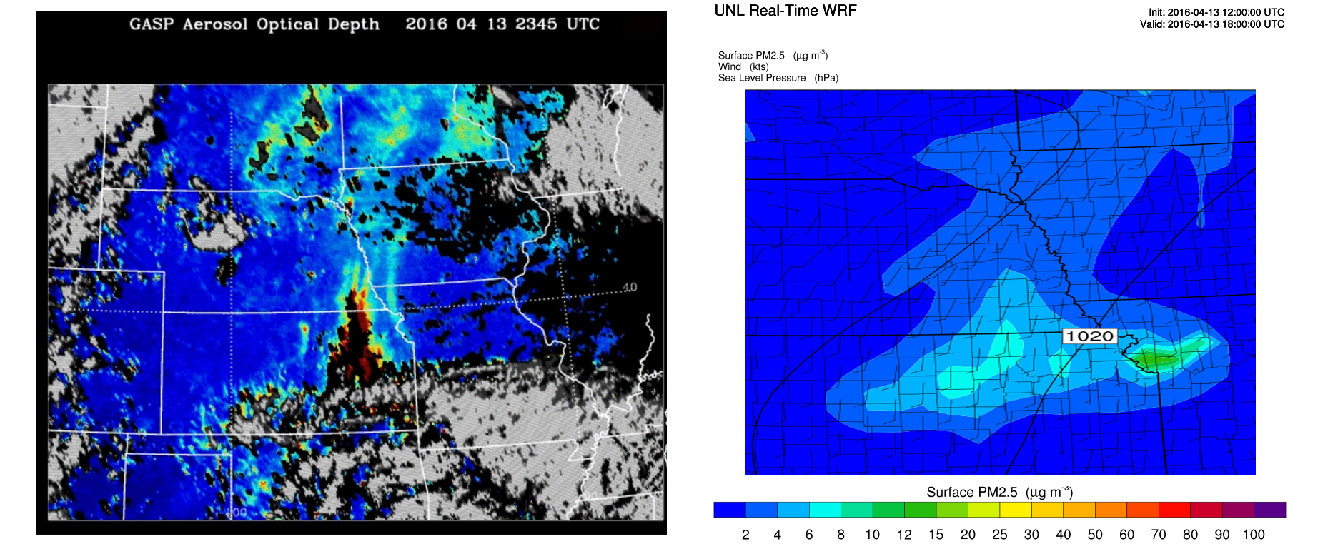
Wang recently pulled up an April 8 image taken by a NASA polar-orbiting satellite clearly showing smoke plumes wafting hundreds of miles to the southeast from fires being used to clear rangeland debris in Kansas. After the wind changed direction, an April 12 satellite image showed the smoke moving northward.
Hourly images taken by a National Oceanic and Atmospheric Administration geo-stationary satellite show smoke particles from the Kansas fires reaching the Lincoln and Omaha areas on April 12 and April 13, having traveled more than 200 miles.
The satellite confirms what eastern Nebraska residents saw and smelled: Environmental Protection Agency monitoring indicated air quality, which is generally good in Nebraska, became unhealthy for children, the elderly and people with sensitivities in the eastern part of the state. For several hours on April 13, it was unhealthy for even those without sensitivities.
Wang has authored several studies on how smoke from prescribed fires and wild fires moves through the atmosphere. He is part of a 10-year, $90 million NASA-funded project to use satellite-based sensors to monitor air pollution throughout North America.
Wang is principal investigator of the Aerosol, Radiation, Remote-sensing and Observation-based Modeling of the Atmosphere, or ARROMA, research group, which uses a planetary vantage point to measure and understand air pollution.
Collaborating with a team led by Hongfeng Yu, assistant professor of engineering computer science, Wang’s team is developing the High Plains Real Time Earth System Modeling Complex, which uses super computing available at the Holland Computing Center to make 72-hour animated forecasts of both weather and air quality. A mobile app is expected to be available within the next few months.
News Release Contacts
Recent News


