· 3 min read
Architecture faculty, University Communication find remote teaching solutions

Looking at different ways to make college course content relevant in a remote learning environment presents challenges for faculty, especially for those disciplines heavily dependent on the traditional, design studio model where one-on-one instruction and feedback are core practices of the pedagogy.
Instructors for the first-year d.Make courses in the College of Architecture are delivering instruction from a different perspective — mainly from above.
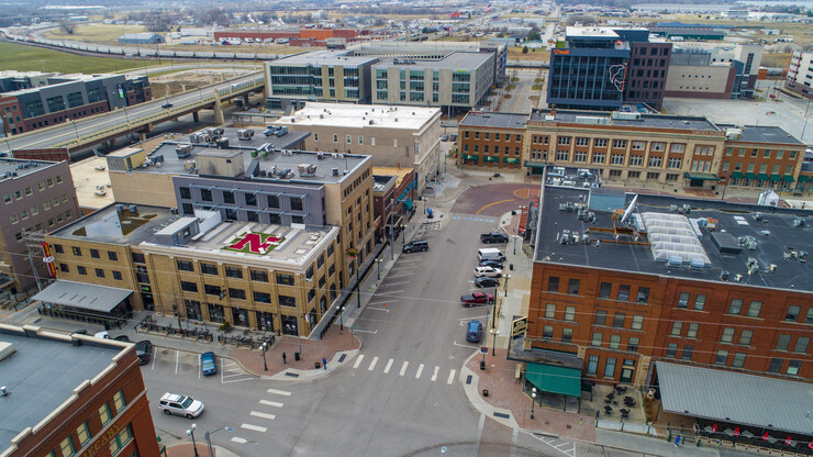
Instructors Nolan Golgert, Ernesto Sanchez Andrade, Matthew Miller and Salvador Lindquist teamed up with Craig Chandler, director of photography for University Communication, to use drone technology to capture location imagery for their students’ final design project set in the iconic alleyway between the Creamery building and the Burkholder Project Gallery of Lincoln’s historic Haymarket.
Usually, for built environment projects such as this, students conduct a comprehensive site inventory and analysis before design concepts or proposals begin. Data for this phase is typically done in-person, with students collecting observational information about the location in its entirety and how its surroundings impact the site.
However, with students learning remotely from all across Nebraska and beyond due to the COVID-19 pandemic, the instructors had to think creatively about how they would assist the students with this inventory and analysis phase.
The d.Make instructors reached out to Chandler with ideas for capturing the necessary project imagery. Chandler, with guidance from the d.Make instructors, took videos and still imagery of the alleyway approach from both the north and south entrances; aerial, rooftop imagery of the entire project area; composite images of each building; and a video alley walk-through simulation to give students a complete understanding of the site in context.
“All of the d.Make instructors couldn’t be happier with how this collaboration turned out,” Golgert said. “Craig’s suggestions and ideas really opened up our eyes to new possibilities. The content he delivered was amazing, and I can’t wait to share it with the students and see the designs they eventually create for this project.”
As Golgert explained, students will utilize Chandler’s drone content to work on a threshold development project that will encompass the vertical and horizontal landscape/field conditions connecting the site’s spaces and their environment in a meaningful way.
“Being a former architecture student myself, I really enjoyed working on this collaboration with the d.Make instructors,” Chandler said. “In a time when our faculty are trying their best to figure out how to deliver instruction remotely, I was more than happy to pitch in and play my part in providing content that would enrich our students’ educational experience.”
“This collaboration is the true definition of synergy,” Sanchez Andrade said. “Craig Chandler’s imagery really helped elevate the content we deliver our students to the next level.”
